Welcome to the Cumbria Way Walk
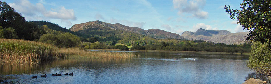
The Cumbria Way is a 73 mile, relatively low-level linear walk through some of the most beautiful & contrasting landscapes that Cumbria has to offer. Linking the historic town of Ulverston and the equally historic city of Carlisle, the route showcases majestic mountain scenery, lakes and tarns, woodland walks, glacial valleys as well as pastoral walks alongside rivers and becks. Along with the traditional hospitality of Cumbrians, great accommodation choices and plenty of fine inns along the route I can guarantee the Cumbria Way will leave you with a massive smile on your face and some fantastic memories.
If you are new to long distance walking or perhaps only have time for a week away then look no further than the Cumbria Way. At 73 miles in length – most of it low-level walking and with only 2 major climbs – the Cumbria Way is a perfect introduction to long distance walking. The route itself is a linear walk from the bustling market town of Ulverston in the south of Cumbria to historic Carlisle in the north and takes in all that Cumbria has to offer. No matter how many times you have walked in the Lake District the route of the Cumbria Way will take you to places you have not visited before and offers stunning views but mainly from a lower level viewpoint rather than from the fell tops.
© Darcy Moore
This website is intended to act as a ‘complete resource centre’ for those new to the route. Hopefully, the site will show you what a fantastic long distance walk the Cumbria Way is and will aid you in the next step of planning your own Cumbria Way trip.
Please note that this site is based on the ‘average’ walk duration of 5 days and consequently the site is built to work on a 5 day walk. You could quite easily amend the duration of your walk if needed although the scarcity of accommodation in some areas along the walk will mean extra careful planning.

Online Route Mapping
Using Google Maps I have marked the full length of the Cumbria Way route and split it into 5 day stages along with the low-level alternative route between Skiddaw House and Caldbeck. Click on the map to open a large version of the Cumbria Way route, zoom in and follow theroute virtually as you plan your own walk. I have tried to be as detailed as possible but if you notice any errors then let me know via the Feedback Form on this website.
Use www.cumbriawaywalk.info to discover more about the Cumbria Way and its history. Find out more about the route it takes and read tips and advice on preparation for your own Cumbria Way walk. Find details on the various maps & guidebooks dedicated to the route as well as the towns & villages along the Cumbria Way. Source your accommodation, discover the optional extras you may wish to add to your trip as well as information on baggage transfers. To whet your appetite for the walk you can view photos taken along the route and much, much more.